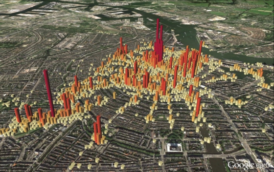
Amsterdam tourist hotspots get mapped, based on Flickr photographs
 Dutch research student Sander van der Drift has analysed 500,000 photos taken by tourists visiting Amsterdam to give new insight into how visitors move around the city and where they congregate
Wageningen University master’s student Van der Drift used photographs on Flickr rather than total visitor numbers to explore how tourists react in Amsterdam. He analysed the time photos were taken and their location and worked out an algorithm to calculate how the photographer had moved though the city.
‘Most pictures were taken near the Iamsterdam letters in the Vondelpark and on the Dam,’ he told the Parool. ‘Then there were the usual suspects like the flower market, Anne Frank House and the Museumplein.’
Amsterdam city council, which is attempting to spread tourists throughout the city in order to relieve the pressure on the most popular places, has now set up a team of eight civil servants to do further research using Van der Drift’s ideas, the Parool reports.
Until now the council has based its strategy towards city centre tourism on museum visitor numbers and hotel stays. Further research could also use information gleaned from Instagram and Twitter, Van der Drift said.
Thank you for donating to DutchNews.nl.
We could not provide the Dutch News service, and keep it free of charge, without the generous support of our readers. Your donations allow us to report on issues you tell us matter, and provide you with a summary of the most important Dutch news each day.
Make a donation